
About Har ki Doon
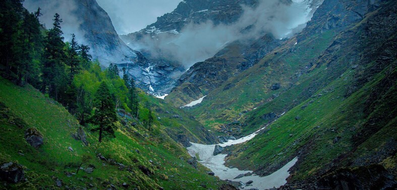
Har ki Dun trek is a resting spot located in the middle of Govind Ballabh Pant National Park, at 3566 m. Har-ki-Dun, surrounded by snow-capped mountains and lush alpine vegetation, is without a doubt one of Uttarakhand’s most beautiful trekking locations, highlighting the state’s incomparable natural splendour. Har ki Doon Trek has been well linked to most of Uttarakhand’s major towns and cities. The following section of the Getting Their guide will show you how to get to Har ki Doon Trek via road, train, or plane.
Har ki Doon trek is an excellent choice for novices and first-timers. You will be walking for around 5-6 hours each day to prepare physically. Every day will include some difficult ascents and descents. Har ki Doon Valley provides breathtaking vistas of unspoiled valleys in the Garhwal Himalayas. It is one of India’s most picturesque destinations, with several hiking opportunities.
Distance of Har Ki Doon Trek
Har Ki Doon trek is a nearly 47-kilometer walk that takes a week to complete. Leaving aside the great distance, this walk will transport you to the natural wonders of the world, where you can relax and enjoy the breathtaking views. You may wander along the orchid paths or stroll across the meadows. The Har Ki Doon trek has been one of the greatest trekking trips that one should experience throughout their holiday.
Height of Har ki Doon trek
Har ki Doon’s trek tallest peak is at a huge height of 11,657 feet. The walk begins in the little settlement of Sankri, at an altitude of around 1,950 metres, and steadily climbs.
Best Time to go Har ki Doon Trek
April to Mid-June or October to Mid-November are the best months to go on the Har ki Doon Trek. Har ki Doon valley is ideally located during in the summer months of April-June and the spring months of middle September and November due to its isolated location. The long hiking path may cause issues during the rainy months of July, August, and September, yet many trekkers like challenging themselves during these months because the route is not tough.
Temperature of Har ki Doon Trek
During the day, the average temp in the Har ki Doon area is from 10 to 15 degrees Celsius. At night, the temperature can dip to as lower as 2 degrees Celsius to 5 ° C. When packing your woollens, keep in mind the temperature as well as the wind direction. Temperatures range from 10°C to 15°C all day and 2°C to -5°C at night.
Main Highlights of Har Ki Doon
- Har ki doon Trek to a height of up to 12,000 feet above sea level to take in the spectacular vistas of the Swargarohini series of peaks.
- Witness beautiful historic culture, mountain views, woods, grasslands, meadows, rivers, streams, and even an alpine lake on the Himalayas’ oldest trek path.
- Trail that follows the same path as the Pandavas on their way to paradise in the Mahabharata.
- Explore historic settlements that are over 2,000 years old and be enthralled by a little glimpse of local life.
- Enjoy the Himalayas’ magical and unique flora and wildlife, as well as the mind-blowing legends of Swargarohini Peak I, II, III, and IV, which bears the famous staircase to heaven.
Things to carry for trekking
Tracking Backpacks, Tracking Shoes & Socks, Trek Pant, Trekking Jackets, Same Clothes, Warmers, Sun Cap, Sunglasses, Gloves, Balaclava, Headlamp, Trekking pole, First Aid Box, Water Bottle, Toiletries, Plastic Bags, Lighter, Ropes, knife, Camping Tent, Sleeping Bags.
Har ki Dun Trek is well linked to most of Uttarakhand’s major towns and cities. The following section of the Getting Their guide will show you how to get to Har ki Doon Trek via road, train, or plane.
By road: – The distance from Dehradun to Har ki Doon is approximately 98.7 kilometres. After arriving in Dehradun, travel to Sankri, which is the starting point for the Har ki Dun walk. When you arrive in Dehradun, you will be managed to pick up and driven to Sankri, then to Taluka, where your journey will begin.
By Air: – Nearest Airport is Jolly Grant Airport in Dehradun.
By Rail: – Nearest Railway station is Dehradun Railway station in Dehradun
Itinerary
Show complete Itinerary
Day 1: – Drive from Dehradun to Sankri (1950 m)
Day 2: – Sankri (1950 m) to Taluka (2108 m) by road; Trek from Taluka (2108 m) to Pauni Garaat (2500 m)
Day 3: – Pauni Garaat (2500 m) to Kalkattiyadhaar (3024 m)
Day 4: – Kalkattiyadhaar (3024 m) to Har Ki Dun (3566 m) and back to Kalkattiyadhaar (3024 m)
Day 5: – Kalkattiyadhaar (3024 m) to Pauni Garaat (2500 m)
Day 6: – Trek from Pauni Garaat (2500 m) to Taluka (2108 m); Taluka (2108 m) to Sankri (1950 m) by road
Day 7: – Sankri (1950 m) to Dehradun (640 m)